Difference between revisions of "Strait of Gibraltar"
Jump to navigation
Jump to search
 This page imported content from Wikipedia on 12 June 2019.
Wikipedia is not affiliated with Wikispooks. Original page source here
(Importing from WP) |
|||
| (3 intermediate revisions by 2 users not shown) | |||
| Line 1: | Line 1: | ||
{{place | {{place | ||
|wikipedia=https://en.wikipedia.org/wiki/Strait_of_Gibraltar | |wikipedia=https://en.wikipedia.org/wiki/Strait_of_Gibraltar | ||
| + | |image=Strait of Gibraltar.png | ||
| + | |locations=Mediterranean Sea, Atlantic Ocean | ||
| + | |constitutes=Strait, Choke point | ||
}} | }} | ||
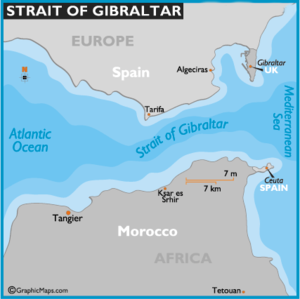
The '''Strait of Gibraltar''' is a narrow strait that connects the [[Atlantic Ocean]] to the [[Mediterranean Sea]] and separates [[Gibraltar]] and peninsular [[Spain]] in [[Europe]] from [[Morocco]] and [[Ceuta]] ([[Spain]]) in [[Africa]]. | The '''Strait of Gibraltar''' is a narrow strait that connects the [[Atlantic Ocean]] to the [[Mediterranean Sea]] and separates [[Gibraltar]] and peninsular [[Spain]] in [[Europe]] from [[Morocco]] and [[Ceuta]] ([[Spain]]) in [[Africa]]. | ||
The two continents are separated by 14.3km of ocean at the Strait's narrowest point. The Strait's depth ranges between 300 and 900 metres<ref>See Robinson, Allan Richard and Paola Malanotte-Rizzoli, ''Ocean Processes in Climate Dynamics: Global and Mediterranean Examples''. Springer, 1994, p. 307, {{ISBN|0-7923-2624-5}}.</ref> which possibly interacted with the lower mean sea level of the last major glaciation 20,000 years ago when the level of the sea is believed to have been lower by 110-120 metres. Ferries cross between the two continents every day in as little as 35 minutes.<ref>''[http://news.bbc.co.uk/1/hi/world/africa/3317149.stm "Europe-Africa rail tunnel agreed"]''</ref> | The two continents are separated by 14.3km of ocean at the Strait's narrowest point. The Strait's depth ranges between 300 and 900 metres<ref>See Robinson, Allan Richard and Paola Malanotte-Rizzoli, ''Ocean Processes in Climate Dynamics: Global and Mediterranean Examples''. Springer, 1994, p. 307, {{ISBN|0-7923-2624-5}}.</ref> which possibly interacted with the lower mean sea level of the last major glaciation 20,000 years ago when the level of the sea is believed to have been lower by 110-120 metres. Ferries cross between the two continents every day in as little as 35 minutes.<ref>''[http://news.bbc.co.uk/1/hi/world/africa/3317149.stm "Europe-Africa rail tunnel agreed"]''</ref> | ||
| + | |||
{{SMWDocs}} | {{SMWDocs}} | ||
==References== | ==References== | ||
Latest revision as of 13:53, 7 August 2023
(Strait, Choke point) | |
|---|---|
 | |
| Locations | Mediterranean Sea, Atlantic Ocean |
The Strait of Gibraltar is a narrow strait that connects the Atlantic Ocean to the Mediterranean Sea and separates Gibraltar and peninsular Spain in Europe from Morocco and Ceuta (Spain) in Africa.
The two continents are separated by 14.3km of ocean at the Strait's narrowest point. The Strait's depth ranges between 300 and 900 metres[1] which possibly interacted with the lower mean sea level of the last major glaciation 20,000 years ago when the level of the sea is believed to have been lower by 110-120 metres. Ferries cross between the two continents every day in as little as 35 minutes.[2]
Related Document
| Title | Type | Publication date | Author(s) | Description |
|---|---|---|---|---|
| Document:So what actually happened in the Strait of Hormuz on 10th July? | social media post | 12 July 2019 | Oliver Tickell | The aggressive posturing of US and UK and the moves to militarise the Strait of Hormuz, taken together with US calls for regime change and other threats to the sovereignty of Iran, constitute a breach of UNCLOS Articles 19 and 39 and are thus unlawful. |
Many thanks to our Patrons who cover ~2/3 of our hosting bill. Please join them if you can.
References
- ↑ See Robinson, Allan Richard and Paola Malanotte-Rizzoli, Ocean Processes in Climate Dynamics: Global and Mediterranean Examples. Springer, 1994, p. 307, ISBN 0-7923-2624-5.
- ↑ "Europe-Africa rail tunnel agreed"
Wikipedia is not affiliated with Wikispooks. Original page source here