Sahara
 | |
The Sahara is the largest hot desert in the world and the third-largest desert overall, smaller only than the deserts of Antarctica and the northern Arctic.[1]
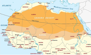
The Sahara Desert covers large parts of Algeria, Chad, Egypt, Libya, Mali, Mauritania, Morocco, Niger, Western Sahara, Sudan and Tunisia. It covers 9 million square kilometres (3,500,000 sq mi), amounting to 31% of Africa but excludes the fertile region on the Mediterranean Sea coast, the Atlas Mountains of the Maghreb, and the Nile Valley in Egypt and the Sudan.
The Sahara stretches from the Red Sea in the east and the Mediterranean in the north to the Atlantic Ocean in the west, where the landscape gradually changes from desert to coastal plains. To the south it is bounded by the Sahel, a belt of semi-arid tropical savanna around the Niger River valley and the Sudan region of sub-Saharan Africa. The Sahara can be divided into several regions, including the Western Sahara, the central Ahaggar Mountains, the Tibesti Mountains, the Aïr Mountains, the Ténéré desert, and the Libyan Desert.[2]
The sky is usually clear above the Sahara Desert, most of which has more than 3,600 hours of bright sunshine per year (over 82% of daylight hours), and a wide area in the eastern part has over 4,000 hours of bright sunshine per year (over 91% of daylight hours). The Sahara has a huge potential for solar energy production.[3]
For several hundred thousand years, the Sahara has alternated between desert and savanna grassland in a 20,000-year cycle caused by the precession of Earth's axis (about 26,000 years) as it rotates around the Sun, which changes the location of the North African monsoon.[4]
References
Wikipedia is not affiliated with Wikispooks. Original page source here