Panama Canal
(Canal, Strategic waterway) | |
|---|---|
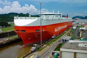
 Panamax ship crossing the Miraflores Locks | |
 | |
| Locations | Panama |
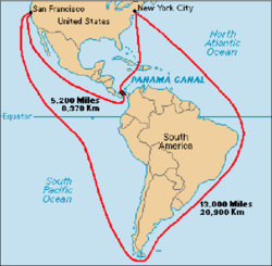
The Panama Canal is an artificial waterway in Panama that connects the Atlantic Ocean with the Pacific Ocean. The canal cuts across the Isthmus of Panama and is a conduit for maritime trade. One of the largest and most difficult engineering projects ever undertaken, the Panama Canal shortcut greatly reduces the time for ships to travel between the Atlantic and Pacific oceans, enabling them to avoid the lengthy, hazardous Cape Horn route around the southernmost tip of South America via the Drake Passage or Strait of Magellan and the even less popular route through the Arctic Archipelago and the Bering Strait.
Construction
The French Compagnie Nouvelle began work on the canal in 1881, but stopped because of engineering problems and a high worker mortality rate. The United States took over the project in 1904 and opened the canal on August 15, 1914.
Alternatives
Other routes, noticeably through Nicaragua were both easier and cheaper to build, healthier, and much shorter, but were abandoned for to line the pockets some few Wall Street financiers who had bought up Compagnie Nouvelle stock on the cheap and was bailed out by US Congress paying $40 million for the rights.[1]
Control
The US continued to control the canal and surrounding Panama Canal Zone until the 1977 Torrijos–Carter Treaties provided for handover to Panama. After a period of joint American–Panamanian control, the canal was taken over by the Panamanian government in 1999. It is now managed and operated by the government-owned Panama Canal Authority.
Panama Canal Zone
The Panama Canal Zone was an unincorporated territory of the United States from 1903 to 1979, centered on the Panama Canal and surrounded by the Republic of Panama.
Over time, the existence of the Canal Zone that cut Panama geographically in half and had its own courts, police, and civil government, became a cause of conflict between the two countries. Major rioting and clashes occurred on May 21, 1958 and on November 3, 1959. Demonstrations occurred at the opening of the Thatcher Ferry Bridge, now known as the Bridge of the Americas, in 1962 and big demonstrations occurred in January 1964. This led to the United States easing its controls in the Zone. For example, Panamanian flags were allowed to be flown alongside American ones. After extensive negotiations, the Canal Zone ceased to exist on October 1, 1979, in compliance with provisions of the Torrijos–Carter Treaties.
The Zone was home for the School of the Americas, where a large percentage of Latin America's dictators and torturists received training in counter-insurgency tactics.
The exclave status allowed the Zone to be used for things that could not legally be done in the continental United States. The area was used to indefinitely detain some Soviet defectors )a role similar to (Guantanamo Bay on Cuba) that were suspected of double crossing[citation needed].