Difference between revisions of "File:MH17+ATO-map.png"
Jump to navigation
Jump to search
(description) |
m (link) |
||
| Line 1: | Line 1: | ||
| − | Derived from File:RNBO_map_16_07.jpg: MH17 track/crash-site overlaid onto ATO (Anti Terrorist Organisation) map from the Organization of the National Security and Defense Council of Ukraine, issued 07/16/2014. Most of the land between the fighting around Snizhne and the Russian border was, at the time of MH17, under the control of Ukrainian Forces. | + | Derived from [[:File:RNBO_map_16_07.jpg]]: MH17 track/crash-site overlaid onto ATO (Anti Terrorist Organisation) map from the Organization of the National Security and Defense Council of Ukraine, issued 07/16/2014. Most of the land between the fighting around Snizhne and the Russian border was, at the time of MH17, under the control of Ukrainian Forces. |
Latest revision as of 15:41, 19 September 2014
Derived from File:RNBO_map_16_07.jpg: MH17 track/crash-site overlaid onto ATO (Anti Terrorist Organisation) map from the Organization of the National Security and Defense Council of Ukraine, issued 07/16/2014. Most of the land between the fighting around Snizhne and the Russian border was, at the time of MH17, under the control of Ukrainian Forces.
File history
Click on a date/time to view the file as it appeared at that time.
| Date/Time | Thumbnail | Dimensions | User | Comment | |
|---|---|---|---|---|---|
| current | 14:19, 19 September 2014 | 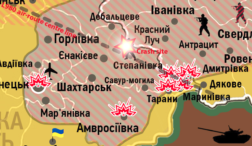 | 833 × 484 (666 KB) | Two Dogs (talk | contribs) | Derived from File:RNBO_map_16_07.jpg |
- You cannot overwrite this file.
File usage
The following 2 pages uses this file: