Difference between revisions of "Weather conditions"
Jump to navigation
Jump to search
(Map compiled from ICAO weather station data at 13:00 UTC) |
m (tweek layout a bit. More can be done with maps but its a steep learning curve) |
||
| Line 1: | Line 1: | ||
{{MH17 timeline event | {{MH17 timeline event | ||
| − | |start= | + | |start=2014/07/17 13:00:00 |
|description=Map compiled from ICAO weather station data at 13:00 UTC | |description=Map compiled from ICAO weather station data at 13:00 UTC | ||
}} | }} | ||
| − | + | ---- | |
| − | + | <div class="thumb tright"> | |
| − | + | <div class="thumbinner"> | |
| − | |||
| − | |||
| − | |||
{{ | {{ | ||
#Display_map:50.4016935,30.4496975~UKKK (KIEV - ZHULYANY)~Visibility 10 km or more,<br />no cloud below 5,000 feet or below the MSA (whichever is greater), <br />no cumulonimbus, and no significant weather phenomena in the aerodrome or its vicinity.<br />No significant changes expected in the near future.; | #Display_map:50.4016935,30.4496975~UKKK (KIEV - ZHULYANY)~Visibility 10 km or more,<br />no cloud below 5,000 feet or below the MSA (whichever is greater), <br />no cumulonimbus, and no significant weather phenomena in the aerodrome or its vicinity.<br />No significant changes expected in the near future.; | ||
| Line 23: | Line 20: | ||
|type= | |type= | ||
}} | }} | ||
| + | <div class="thumbcaption" style="text-align:center;"><small>''Use controls or mouse to pan & resize. Click flags for more information''</small> | ||
| + | </div></div></div> | ||
| + | |||
| + | |||
| + | This map has been compiled from ICAO weather station data via the following sources: | ||
| + | *ogimet.com [http://www.ogimet.com/display_metars2.php?lang=en&lugar=UKKK&tipo=ALL&ord=REV&nil=SI&fmt=html&ano=2014&mes=07&day=17&hora=01&anof=2014&mesf=07&dayf=17&horaf=16&minf=59&send=send Example for UKKK KIEV - ZHULYANY] | ||
| + | *[http://www.flightutilities.com/MRonline.aspx flightutilities.com] metar decoder | ||
| + | *[http://heras-gilsanz.com/manuel/METAR-Decoder.html gilsanz.com] another metar decoder | ||
| + | *airportnavfinder.com [http://airportnavfinder.com/airport/UKKK/ Example for UKKK KIEV - ZHULYANY] | ||
UKCW - LUHANSK INTL (ll=48.4173805,39.3741265) and UKCC DONETSK - (ll=48.073611,37.7397225) did not report weather conditions at this time. | UKCW - LUHANSK INTL (ll=48.4173805,39.3741265) and UKCC DONETSK - (ll=48.073611,37.7397225) did not report weather conditions at this time. | ||
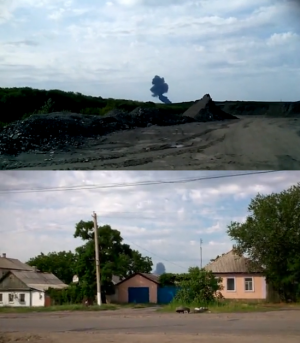
[[File:MH17 Crash Weather.png|thumbnail|Stills from amateur video showing weather conditions at the time of the crash of MH17]] | [[File:MH17 Crash Weather.png|thumbnail|Stills from amateur video showing weather conditions at the time of the crash of MH17]] | ||
Revision as of 13:33, 7 September 2014
Template:MH17badge
This is a Malaysia Airlines Flight 17 timeline event page
(All times are UTC)
Add another event | Return to the timeline
| Start | 2014/07/17 13:00:00 |
|---|---|
| End | |
| Description | Map compiled from ICAO weather station data at 13:00 UTC |
NB: Use Edit with form above to add additional information links, references etc to this event
Loading map...
Use controls or mouse to pan & resize. Click flags for more information
This map has been compiled from ICAO weather station data via the following sources:
- ogimet.com Example for UKKK KIEV - ZHULYANY
- flightutilities.com metar decoder
- gilsanz.com another metar decoder
- airportnavfinder.com Example for UKKK KIEV - ZHULYANY
UKCW - LUHANSK INTL (ll=48.4173805,39.3741265) and UKCC DONETSK - (ll=48.073611,37.7397225) did not report weather conditions at this time.
