Edit this page
This "sandbox" page is to allow you to carry out experiments. Please feel free to try your skills at formatting here. If you want to learn more about how to edit a wiki, please read this introduction or the tutorial at Wikipedia. For in-depth experimentation, design and testing of templates etc, please use the separate sandbox wiki
To edit, click here or "edit" at the top of the page and make your changes. Then, click the "Show Preview", "Cancel", or "Save page" button above and below the editing box. Previewed or saved work will appear under the "Testing Area" heading below. Please do not add material that is offensive, copyrighted, or libelous.
Please be sure not to change anything on the top line of the edit box.
Content added here will not stay permanently; this page may be cleared at any time.
This is for single page test edits, - for more complex tests, go to Test:Test, where you will have more room, and might find others able to help you.
Testing Area
SitRep: WIP for MH17 Timeline event
Examples of Ukrainian Forces active in the "area controlled by pro-Russian separatists", leading up to and including the 17th July 2014/
Loading map...
{"minzoom":false,"maxzoom":false,"mappingservice":"leaflet","width":"600px","height":"400px","centre":false,"title":"","label":"","icon":"","visitedicon":"","lines":[],"polygons":[],"circles":[],"rectangles":[],"wmsoverlay":false,"copycoords":false,"static":false,"zoom":8,"defzoom":14,"layers":["OpenStreetMap"],"overlaylayers":[],"resizable":false,"enablefullscreen":false,"scrollwheelzoom":true,"markercluster":false,"clustermaxzoom":20,"clusterzoomonclick":true,"clustermaxradius":80,"clusterspiderfy":true,"geojson":"","locations":[{"text":"\u003Cb\u003E\u003Cdiv class=\"mw-parser-output\"\u003E\u003Cp\u003EMH17 Crash site\n\u003C/p\u003E\u003C/div\u003E\u003C/b\u003E\u003Chr /\u003E\u003Cdiv class=\"mw-parser-output\"\u003E\u003Cp\u003ESituated @15km NE of the last ADS-B coordinates\u003Cbr /\u003Eabove the town of Snizhne and @53km from\u003Cbr /\u003Ethe Tamak waypoint on the Russian border\n\u003C/p\u003E\u003C/div\u003E","title":"MH17 Crash site\n","link":"","lat":48.126455,"lon":38.623509,"icon":""},{"text":"\u003Cb\u003E\u003Cdiv class=\"mw-parser-output\"\u003E\u003Cp\u003EMarynivka\n\u003C/p\u003E\u003C/div\u003E\u003C/b\u003E\u003Chr /\u003E\u003Cdiv class=\"mw-parser-output\"\u003E\u003Cp\u003EUkrainian government-controlled town\n\u003C/p\u003E\u003C/div\u003E","title":"Marynivka\n","link":"","lat":47.90484,"lon":38.84162,"icon":""},{"text":"\u003Cb\u003E\u003Cdiv class=\"mw-parser-output\"\u003E\u003Cp\u003EStepanivka\n\u003C/p\u003E\u003C/div\u003E\u003C/b\u003E\u003Chr /\u003E\u003Cdiv class=\"mw-parser-output\"\u003E\u003Cp\u003EMiltia surrounded by Ukrainian government forces\n\u003C/p\u003E\u003C/div\u003E","title":"Stepanivka\n","link":"","lat":47.92478,"lon":38.80076,"icon":""},{"text":"\u003Cb\u003E\u003Cdiv class=\"mw-parser-output\"\u003E\u003Cp\u003EBUKs\n\u003C/p\u003E\u003C/div\u003E\u003C/b\u003E\u003Chr /\u003E\u003Cdiv class=\"mw-parser-output\"\u003E\u003Cp\u003E3-4 missile units of Ukrainian Army\n\u003C/p\u003E\u003C/div\u003E","title":"BUKs\n","link":"","lat":47.981,"lon":38.467,"icon":""},{"text":"\u003Cb\u003E\u003Cdiv class=\"mw-parser-output\"\u003E\u003Cp\u003ESnizhne\n\u003C/p\u003E\u003C/div\u003E\u003C/b\u003E\u003Chr /\u003E\u003Cdiv class=\"mw-parser-output\"\u003E\u003Cp\u003EAircraft rocket attack on 15 July that killed at least eleven people and damaged many homes\n\u003C/p\u003E\u003C/div\u003E","title":"Snizhne\n","link":"","lat":48.0403,"lon":38.7728,"icon":""},{"text":"\u003Cb\u003E\u003Cdiv class=\"mw-parser-output\"\u003E\u003Cp\u003ETarany\n\u003C/p\u003E\u003C/div\u003E\u003C/b\u003E\u003Chr /\u003E\u003Cdiv class=\"mw-parser-output\"\u003E\u003Cp\u003EFighting reported\n\u003C/p\u003E\u003C/div\u003E","title":"Tarany\n","link":"","lat":47.88782,"lon":38.78399,"icon":""},{"text":"\u003Cb\u003E\u003Cdiv class=\"mw-parser-output\"\u003E\u003Cp\u003EShakhtarsk\n\u003C/p\u003E\u003C/div\u003E\u003C/b\u003E\u003Chr /\u003E\u003Cdiv class=\"mw-parser-output\"\u003E\u003Cp\u003EFighting reported\n\u003C/p\u003E\u003C/div\u003E","title":"Shakhtarsk\n","link":"","lat":48.06219,"lon":38.41644,"icon":""},{"text":"\u003Cb\u003E\u003Cdiv class=\"mw-parser-output\"\u003E\u003Cp\u003ELuhansk Airport\n\u003C/p\u003E\u003C/div\u003E\u003C/b\u003E\u003Chr /\u003E\u003Cdiv class=\"mw-parser-output\"\u003E\u003Cp\u003Eunder Kiev control since 14 Jul\n\u003C/p\u003E\u003C/div\u003E","title":"Luhansk Airport\n","link":"","lat":48.4184,"lon":39.3735,"icon":""},{"text":"\u003Cb\u003E\u003Cdiv class=\"mw-parser-output\"\u003E\u003Cp\u003EAmvrosievka\n\u003C/p\u003E\u003C/div\u003E\u003C/b\u003E\u003Chr /\u003E\u003Cdiv class=\"mw-parser-output\"\u003E\u003Cp\u003EUkrainian controlled\n\u003C/p\u003E\u003C/div\u003E","title":"Amvrosievka\n","link":"","lat":47.7859,"lon":38.4824,"icon":""},{"text":"\u003Cb\u003E\u003Cdiv class=\"mw-parser-output\"\u003E\u003Cp\u003EKrasnodon\n\u003C/p\u003E\u003C/div\u003E\u003C/b\u003E\u003Chr /\u003E\u003Cdiv class=\"mw-parser-output\"\u003E\u003Cp\u003EFighting reported\n\u003C/p\u003E\u003C/div\u003E","title":"Krasnodon\n","link":"","lat":48.2988,"lon":39.7322,"icon":""},{"text":"\u003Cb\u003E\u003Cdiv class=\"mw-parser-output\"\u003E\u003Cp\u003EMetallist\n\u003C/p\u003E\u003C/div\u003E\u003C/b\u003E\u003Chr /\u003E\u003Cdiv class=\"mw-parser-output\"\u003E\u003Cp\u003EFighting reported\n\u003C/p\u003E\u003C/div\u003E","title":"Metallist\n","link":"","lat":48.6234,"lon":39.2777,"icon":""},{"text":"\u003Cb\u003E\u003Cdiv class=\"mw-parser-output\"\u003E\u003Cp\u003ESabovka\n\u003C/p\u003E\u003C/div\u003E\u003C/b\u003E\u003Chr /\u003E\u003Cdiv class=\"mw-parser-output\"\u003E\u003Cp\u003Eliberated from the punitive forces on the 15th\n\u003C/p\u003E\u003C/div\u003E","title":"Sabovka\n","link":"","lat":48.5774,"lon":39.1382,"icon":""},{"text":"\u003Cb\u003E\u003Cdiv class=\"mw-parser-output\"\u003E\u003Cp\u003ERoskoshnoye\n\u003C/p\u003E\u003C/div\u003E\u003C/b\u003E\u003Chr /\u003E\u003Cdiv class=\"mw-parser-output\"\u003E\u003Cp\u003Eliberated from the punitive forces on the 15th\n\u003C/p\u003E\u003C/div\u003E","title":"Roskoshnoye\n","link":"","lat":48.4881,"lon":39.272,"icon":""},{"text":"\u003Cb\u003E\u003Cdiv class=\"mw-parser-output\"\u003E\u003Cp\u003ESverdlovsk\n\u003C/p\u003E\u003C/div\u003E\u003C/b\u003E\u003Chr /\u003E\u003Cdiv class=\"mw-parser-output\"\u003E\u003Cp\u003EFighting reported\n\u003C/p\u003E\u003C/div\u003E","title":"Sverdlovsk\n","link":"","lat":48.076,"lon":39.656,"icon":""},{"text":"\u003Cb\u003E\u003Cdiv class=\"mw-parser-output\"\u003E\u003Cp\u003EKarlovka\n\u003C/p\u003E\u003C/div\u003E\u003C/b\u003E\u003Chr /\u003E\u003Cdiv class=\"mw-parser-output\"\u003E\u003Cp\u003EFighting reported\n\u003C/p\u003E\u003C/div\u003E","title":"Karlovka\n","link":"","lat":48.1125,"lon":37.4916,"icon":""},{"text":"\u003Cb\u003E\u003Cdiv class=\"mw-parser-output\"\u003E\u003Cp\u003EDonetsk Airport\n\u003C/p\u003E\u003C/div\u003E\u003C/b\u003E\u003Chr /\u003E\u003Cdiv class=\"mw-parser-output\"\u003E\u003Cp\u003EUkrainian government-controlled\n\u003C/p\u003E\u003C/div\u003E","title":"Donetsk Airport\n","link":"","lat":48.06824,"lon":37.74265,"icon":""},{"text":"\u003Cb\u003E\u003Cdiv class=\"mw-parser-output\"\u003E\u003Cp\u003ESaur Mogila\n\u003C/p\u003E\u003C/div\u003E\u003C/b\u003E\u003Chr /\u003E\u003Cdiv class=\"mw-parser-output\"\u003E\u003Cp\u003EUkrainian troops, trapped\n\u003C/p\u003E\u003C/div\u003E","title":"Saur Mogila\n","link":"","lat":47.922141,"lon":38.740269,"icon":""}],"imageoverlays":null}
Additional plot points from Igor Strelkov and Militia Briefings, July 14-16, 2014
Losses
Losses in Donetsk and the Lugansk regions (for the period from July 9-15, 2014)
| Losses: |
Ukrainian |
Militia
|
| Killed in Action |
1600 |
48
|
| Wounded in Action |
4723 |
64
|
| Tanks |
35 |
2
|
| Armoured Battle Vehicles |
96 |
0
|
| Artillery |
38 |
5
|
| Aircraft |
7 |
n/a
|
| Helicopters |
2 |
n/a
|
| Automobiles |
104 |
8
|
Arsen Avakov (Minister of Interior) and V. Gritsak (Head of the ATO)[1]
Luhansk
The airport had been under Kiev control since 14 Jul when Ukraine forces had ended a rebel blockade.[2]
Shakhtarsk
Ukrainian forces and rebels had been battling in the Shakhtarsk area for several days but the town was still in rebel hands.
[3]
[4]
Marynivka
DPR-affiliated insurgents launched an offensive on neighbouring government-controlled Marynivka (47.90484,38.84162) from village of Stepanivka (47.92478,38.80076) and Savur-Mohyla/Savur-Mogila/Saur-Mogila/Savur-Mogila on 16 July.[5]Marynivka is a border town located in the southern Donetsk Oblast. Its position on the border made control of it important to maintaining insurgent supply-lines. Insurgents launched an offensive on National Guard of Ukraine positions in the town on 16 July, after breaking through encirclement by government forces in neighbouring Stepanivka.
Two days after the downing of a government An-26 transport plane, Ukrainian warplanes had been given the go-ahead to resume flights over the east, Lysenko said.
Kiev says it believes the transporter was hit by a missile fired from Russia. A separate SU-25 fighter plane was hit by a rebel rocket on the 16th, but the pilot made a successful emergency landing and there was only slight damage to the aircraft, the defence ministry said. No-one was hurt. [6] Fighting also spread to the nearby village of Tarany (47.88782,38.78399).[7]During this offensive, the insurgents used tanks, mortars, and anti-tank missiles against government forces. Insurgents shelled Marynivka until the National Guard was able to repel their offensive and force them to retreat to Stepanivka.[8] Later on, the insurgents said that had recaptured Marynivka. [9] Insurgent spokesman Sergei Kavtaradze said that fifteen insurgents had one insurgent had been killed, while fifteen were injured. Insurgent commander Igor Girkin said that DPR insurgents destroyed two Ukrainian armoured vehicles and captured one.[10] Large numbers of Ukrainian troops, trapped near Saur Mogila, were reportedly attempting to fight their way out of the encirclement.[11] Ukrainian forces came under continued attack by the insurgents in Marynivka, despite managing to hold onto control of it on 16 July. On the day after the first insurgent offensive, government forces repelled another four attacks, and destroyed three tanks, two armoured personnel carriers, and two other combat vehicles.[12]
See also animation
MH17 Weather Map at 13:00 UTC
This map has been compiled from ICAO weather station data via the following sources:
- ogimet.com Example for UKKK KIEV - ZHULYANY
- flightutilities.com metar decoder
- gilsanz.com another metar decoder
- airportnavfinder.com Example for UKKK KIEV - ZHULYANY
Loading map...
{"minzoom":false,"maxzoom":false,"mappingservice":"leaflet","width":"680px","height":"340px","centre":false,"title":"","label":"","icon":"","visitedicon":"","lines":[],"polygons":[],"circles":[],"rectangles":[],"wmsoverlay":false,"copycoords":false,"static":false,"zoom":6,"defzoom":14,"layers":["OpenStreetMap"],"overlaylayers":[],"resizable":false,"enablefullscreen":false,"scrollwheelzoom":true,"markercluster":false,"clustermaxzoom":20,"clusterzoomonclick":true,"clustermaxradius":80,"clusterspiderfy":true,"geojson":"","locations":[{"text":"\u003Cb\u003E\u003Cdiv class=\"mw-parser-output\"\u003E\u003Cp\u003EUKKK (KIEV - ZHULYANY)\n\u003C/p\u003E\u003C/div\u003E\u003C/b\u003E\u003Chr /\u003E\u003Cdiv class=\"mw-parser-output\"\u003E\u003Cp\u003EVisibility 10 km or more,\u003Cbr /\u003Eno cloud below 5,000 feet or below the MSA (whichever is greater), \u003Cbr /\u003Eno cumulonimbus, and no significant weather phenomena in the aerodrome or its vicinity.\u003Cbr /\u003ENo significant changes expected in the near future.\n\u003C/p\u003E\u003C/div\u003E","title":"UKKK (KIEV - ZHULYANY)\n","link":"","lat":50.4016935,"lon":30.4496975,"icon":""},{"text":"\u003Cb\u003E\u003Cdiv class=\"mw-parser-output\"\u003E\u003Cp\u003EUKHH (OSNOVA INTL)\n\u003C/p\u003E\u003C/div\u003E\u003C/b\u003E\u003Chr /\u003E\u003Cdiv class=\"mw-parser-output\"\u003E\u003Cp\u003EMinimum horizontal visibility: 10 km or more.\u003Cbr /\u003EClouds: A few (1-2 oktas), at 3300 feet above aerodrome level (1006 meters), cumulonimbus.\u003Cbr /\u003EClouds: Broken sky (5-7 oktas), at 20000 feet above aerodrome level (6096 meters).\n\u003C/p\u003E\u003C/div\u003E","title":"UKHH (OSNOVA INTL)\n","link":"","lat":49.9247865,"lon":36.2899875,"icon":""},{"text":"\u003Cb\u003E\u003Cdiv class=\"mw-parser-output\"\u003E\u003Cp\u003EUKON (MYKOLAIV INTL)\n\u003C/p\u003E\u003C/div\u003E\u003C/b\u003E\u003Chr /\u003E\u003Cdiv class=\"mw-parser-output\"\u003E\u003Cp\u003EMinimum horizontal visibility: 10 km or more.\u003Cbr /\u003EWeather: In the vicinity, Thunderstorms .\u003Cbr /\u003EClouds: Scattered (3-4 oktas), at 2600 feet above aerodrome level (792 meters), cumulonimbus.\u003Cbr /\u003EClouds: Broken sky (5-7 oktas), at 10000 feet above aerodrome level (3048 meters).\n\u003C/p\u003E\u003C/div\u003E","title":"UKON (MYKOLAIV INTL)\n","link":"","lat":47.058131,"lon":31.919828,"icon":""},{"text":"\u003Cb\u003E\u003Cdiv class=\"mw-parser-output\"\u003E\u003Cp\u003EUKDR (LOZUVATKA INTL)\n\u003C/p\u003E\u003C/div\u003E\u003C/b\u003E\u003Chr /\u003E\u003Cdiv class=\"mw-parser-output\"\u003E\u003Cp\u003EVisibility 10 km or more,\u003Cbr /\u003Eno cloud below 5,000 feet or below the MSA (whichever is greater), \u003Cbr /\u003Eno cumulonimbus, and no significant weather phenomena in the aerodrome or its vicinity.\n\u003C/p\u003E\u003C/div\u003E","title":"UKDR (LOZUVATKA INTL)\n","link":"","lat":48.043333,"lon":33.21,"icon":""},{"text":"\u003Cb\u003E\u003Cdiv class=\"mw-parser-output\"\u003E\u003Cp\u003EUKDD (Dnipropetrovsk Intl)\n\u003C/p\u003E\u003C/div\u003E\u003C/b\u003E\u003Chr /\u003E\u003Cdiv class=\"mw-parser-output\"\u003E\u003Cp\u003EMinimum horizontal visibility: 10 km or more.\u003Cbr /\u003EWeather: In the vicinity, Thunderstorms .\u003Cbr /\u003EClouds: Scattered (3-4 oktas), at 3300 feet above aerodrome level (1006 meters), cumulonimbus.\u003Cbr /\u003EClouds: Broken sky (5-7 oktas), at 10000 feet above aerodrome level (3048 meters).\n\u003C/p\u003E\u003C/div\u003E","title":"UKDD (Dnipropetrovsk Intl)\n","link":"","lat":48.357222,"lon":35.100556,"icon":""},{"text":"\u003Cb\u003E\u003Cdiv class=\"mw-parser-output\"\u003E\u003Cp\u003EUKDE (ZAPORIZHZHIA INTL)\n\u003C/p\u003E\u003C/div\u003E\u003C/b\u003E\u003Chr /\u003E\u003Cdiv class=\"mw-parser-output\"\u003E\u003Cp\u003EClouds: Scattered (3-4 oktas), at 3300 feet above aerodrome level (1006 meters), cumulonimbus.\u003Cbr /\u003EClouds: Broken sky (5-7 oktas), at 3300 feet above aerodrome level (1006 meters).\u003Cbr /\u003ERunway state: Runway 02 Left: wet or water patches, contamination 10% or less, deposit is 3 mm deep, friction coefficient 0.70\u003Cbr /\u003EThe following weather phenomena are expected to arise temporarily:\u003Cbr /\u003EWind: Variable in direction, Speed: 10 m/s, with Gusts of maximum speed 15 m/s\u003Cbr /\u003EVisibility: 2100 m\n\u003C/p\u003E\u003C/div\u003E","title":"UKDE (ZAPORIZHZHIA INTL)\n","link":"","lat":47.8670045,"lon":35.315693,"icon":""},{"text":"\u003Cb\u003E\u003Cdiv class=\"mw-parser-output\"\u003E\u003Cp\u003EURRR (ROSTOV - RUSSIA)\n\u003C/p\u003E\u003C/div\u003E\u003C/b\u003E\u003Chr /\u003E\u003Cdiv class=\"mw-parser-output\"\u003E\u003Cp\u003EMinimum horizontal visibility: 10 km or more.\u003Cbr /\u003EClouds: A few (1-2 oktas), at 4000 feet above aerodrome level (1219 meters).\u003Cbr /\u003EClouds: Broken sky (5-7 oktas), at 10000 feet above aerodrome level (3048 meters).\n\u003C/p\u003E\u003C/div\u003E","title":"URRR (ROSTOV - RUSSIA)\n","link":"","lat":47.2571845,"lon":39.8175555,"icon":""},{"text":"\u003Cb\u003E\u003Cdiv class=\"mw-parser-output\"\u003E\u003Cp\u003ESnizhne\n\u003C/p\u003E\u003C/div\u003E\u003C/b\u003E\u003Chr /\u003E\u003Cdiv class=\"mw-parser-output\"\u003E\u003Cp\u003EUS intel/satellite location for rebel BUK launcher\n\u003C/p\u003E\u003C/div\u003E","title":"Snizhne\n","link":"","lat":48.0403,"lon":38.7728,"icon":""}],"imageoverlays":null}
UKCW - LUHANSK INTL (ll=48.4173805,39.3741265) and UKCC DONETSK - (ll=48.073611,37.7397225) did not report weather conditions at this time.
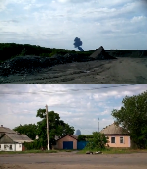
Stills from amateur video showing weather conditions at the time of the crash of MH17
Google Maps
This is an attempt to get the map to display something other than the standard red lollipop, but it does not work:
Loading map...
{"minzoom":false,"maxzoom":false,"mappingservice":"leaflet","width":"680px","height":"340px","centre":false,"title":"","label":"","icon":"","visitedicon":"","lines":[],"polygons":[],"circles":[],"rectangles":[],"wmsoverlay":false,"copycoords":false,"static":false,"zoom":false,"defzoom":14,"layers":["OpenStreetMap"],"overlaylayers":[],"resizable":false,"enablefullscreen":false,"scrollwheelzoom":true,"markercluster":false,"clustermaxzoom":20,"clusterzoomonclick":true,"clustermaxradius":80,"clusterspiderfy":true,"geojson":"","locations":[{"text":"\u003Cb\u003E\u003Cdiv class=\"mw-parser-output\"\u003E\u003Cp\u003EMH17 Crash site\n\u003C/p\u003E\u003C/div\u003E\u003C/b\u003E\u003Chr /\u003E\u003Cdiv class=\"mw-parser-output\"\u003E\u003Cp\u003ESituated @15km NE of the last ADS-B coordinates\u003Cbr /\u003Eabove the town of Snizhne and @53km from\u003Cbr /\u003Ethe Tamak waypoint on the Russian border\n\u003C/p\u003E\u003C/div\u003E","title":"MH17 Crash site\n","link":"","lat":48.126455,"lon":38.623509,"icon":"https://wikispooks.com/w/images/2/29/Mobilephonetower.png"},{"text":"\u003Cb\u003E\u003Cdiv class=\"mw-parser-output\"\u003E\u003Cp\u003ETAMAK\n\u003C/p\u003E\u003C/div\u003E\u003C/b\u003E\u003Chr /\u003E\u003Cdiv class=\"mw-parser-output\"\u003E\u003Cp\u003Enavigation waypoint\n\u003C/p\u003E\u003C/div\u003E","title":"TAMAK\n","link":"","lat":47.8538,"lon":39.20381,"icon":"https://wikispooks.com/w/images/2/29/Mobilephonetower.png"}],"imageoverlays":null}
Neither does this:
Loading map...
{"minzoom":false,"maxzoom":false,"mappingservice":"leaflet","width":"auto","height":350,"centre":false,"title":"","label":"","icon":"","visitedicon":"","lines":[],"polygons":[],"circles":[],"rectangles":[],"wmsoverlay":false,"copycoords":false,"static":false,"zoom":false,"defzoom":14,"layers":["OpenStreetMap"],"overlaylayers":[],"resizable":false,"enablefullscreen":false,"scrollwheelzoom":true,"markercluster":false,"clustermaxzoom":20,"clusterzoomonclick":true,"clustermaxradius":80,"clusterspiderfy":true,"geojson":"","locations":[{"text":"\u003Cb\u003E\u003Cdiv class=\"mw-parser-output\"\u003E\u003Cp\u003EMoscow\n\u003C/p\u003E\u003C/div\u003E\u003C/b\u003E\u003Chr /\u003E\u003Cdiv class=\"mw-parser-output\"\u003E\u003Cp\u003EA city in Russia\n\u003C/p\u003E\u003C/div\u003E","title":"Moscow\n","link":"","lat":55.7505412,"lon":37.6174782,"icon":""},{"text":"\u003Cb\u003E\u003Cdiv class=\"mw-parser-output\"\u003E\u003Cp\u003ENew York city\n\u003C/p\u003E\u003C/div\u003E\u003C/b\u003E\u003Chr /\u003E\u003Cdiv class=\"mw-parser-output\"\u003E\u003C/div\u003E","title":"New York city\n","link":"","lat":40.7127281,"lon":-74.0060152,"icon":""},{"text":"\u003Cb\u003E\u003Cdiv class=\"mw-parser-output\"\u003E\u003Cp\u003E\u003Ca href=\"/wiki/London\" title=\"London\"\u003ELondon\u003C/a\u003E\n\u003C/p\u003E\u003C/div\u003E\u003C/b\u003E\u003Chr /\u003E\u003Cdiv class=\"mw-parser-output\"\u003E\u003Cp\u003ECapital of England\n\u003C/p\u003E\u003C/div\u003E","title":"London\n","link":"","lat":51.4893335,"lon":-0.14405508452768728,"icon":"https://wikispooks.com/w/images/2/29/Mobilephonetower.png"},{"text":"\u003Cb\u003E\u003Cdiv class=\"mw-parser-output\"\u003E\u003C/div\u003E\u003C/b\u003E\u003Chr /\u003E\u003Cdiv class=\"mw-parser-output\"\u003E\u003C/div\u003E","title":"","link":"","lat":50.8465573,"lon":4.351697,"icon":""},{"text":"\u003Cb\u003E\u003Cdiv class=\"mw-parser-output\"\u003E\u003Cp\u003EMali\n\u003C/p\u003E\u003C/div\u003E\u003C/b\u003E\u003Chr /\u003E\u003Cdiv class=\"mw-parser-output\"\u003E\u003Cp\u003ELabel\n\u003C/p\u003E\u003C/div\u003E","title":"Mali\n","link":"","lat":16.3700359,"lon":-2.2900239,"icon":"/w/images/2/29/Mobilephonetower.png"}],"imageoverlays":null}
Loading map...
{"minzoom":false,"maxzoom":false,"mappingservice":"leaflet","width":"408px","height":"340px","centre":false,"title":"","label":"","icon":"","visitedicon":"","lines":[],"polygons":[],"circles":[],"rectangles":[],"wmsoverlay":false,"copycoords":false,"static":false,"zoom":9,"defzoom":14,"layers":["OpenStreetMap"],"overlaylayers":[],"resizable":false,"enablefullscreen":false,"scrollwheelzoom":true,"markercluster":false,"clustermaxzoom":20,"clusterzoomonclick":true,"clustermaxradius":80,"clusterspiderfy":true,"geojson":"","locations":[{"text":"\u003Cb\u003E\u003Cdiv class=\"mw-parser-output\"\u003E\u003Cp\u003EMH17 Crash site\n\u003C/p\u003E\u003C/div\u003E\u003C/b\u003E\u003Chr /\u003E\u003Cdiv class=\"mw-parser-output\"\u003E\u003Cp\u003ESituated @15km NE of the last ADS-B coordinates\u003Cbr /\u003Eabove the town of Snizhne and @53km from\u003Cbr /\u003Ethe Tamak waypoint on the Russian border\n\u003C/p\u003E\u003C/div\u003E","title":"MH17 Crash site\n","link":"","lat":48.126455,"lon":38.623509,"icon":""},{"text":"\u003Cb\u003E\u003Cdiv class=\"mw-parser-output\"\u003E\u003Cp\u003EEnakievo\n\u003C/p\u003E\u003C/div\u003E\u003C/b\u003E\u003Chr /\u003E\u003Cdiv class=\"mw-parser-output\"\u003E\u003Cp\u003EUkrainian SBU location for rebel shootdown\u003Cbr /\u003Efrom the intercepted phone calls\n\u003C/p\u003E\u003C/div\u003E","title":"Enakievo\n","link":"","lat":48.219,"lon":38.216,"icon":""},{"text":"\u003Cb\u003E\u003Cdiv class=\"mw-parser-output\"\u003E\u003Cp\u003EChernukhino\n\u003C/p\u003E\u003C/div\u003E\u003C/b\u003E\u003Chr /\u003E\u003Cdiv class=\"mw-parser-output\"\u003E\u003Cp\u003EUkrainian SBU location for rebel base\u003Cbr /\u003Efrom the intercepted phone calls\n\u003C/p\u003E\u003C/div\u003E","title":"Chernukhino\n","link":"","lat":48.33,"lon":38.487,"icon":""},{"text":"\u003Cb\u003E\u003Cdiv class=\"mw-parser-output\"\u003E\u003Cp\u003EBUKs\n\u003C/p\u003E\u003C/div\u003E\u003C/b\u003E\u003Chr /\u003E\u003Cdiv class=\"mw-parser-output\"\u003E\u003Cp\u003E3-4 missile units of Ukrainian Army\n\u003C/p\u003E\u003C/div\u003E","title":"BUKs\n","link":"","lat":47.981,"lon":38.467,"icon":""},{"text":"\u003Cb\u003E\u003Cdiv class=\"mw-parser-output\"\u003E\u003Cp\u003ESnizhne\n\u003C/p\u003E\u003C/div\u003E\u003C/b\u003E\u003Chr /\u003E\u003Cdiv class=\"mw-parser-output\"\u003E\u003Cp\u003EUS intel/satellite location for rebel BUK launcher\n\u003C/p\u003E\u003C/div\u003E","title":"Snizhne\n","link":"","lat":48.0403,"lon":38.7728,"icon":""},{"text":"\u003Cb\u003E\u003Cdiv class=\"mw-parser-output\"\u003E\u003Cp\u003ESu-25\n\u003C/p\u003E\u003C/div\u003E\u003C/b\u003E\u003Chr /\u003E\u003Cdiv class=\"mw-parser-output\"\u003E\u003Cp\u003EShot down the previous day\u003Cbr /\u003Epossible subject of phone intercepts?\n\u003C/p\u003E\u003C/div\u003E","title":"Su-25\n","link":"","lat":48.31,"lon":38.047,"icon":""}],"imageoverlays":null}
--Two Dogs (talk) 15:52, 5 September 2014 (IST)
Or these, that were generated at https://wikispooks.com/wiki/Special:MapEditor and work OK on that page
Loading map...
{"minzoom":false,"maxzoom":false,"mappingservice":"leaflet","width":"auto","height":350,"centre":false,"title":"","label":"","icon":"","visitedicon":"","lines":[],"polygons":[],"circles":[],"rectangles":[],"wmsoverlay":false,"copycoords":false,"static":false,"zoom":false,"defzoom":14,"layers":["OpenStreetMap"],"overlaylayers":[],"resizable":false,"enablefullscreen":false,"scrollwheelzoom":true,"markercluster":false,"clustermaxzoom":20,"clusterzoomonclick":true,"clustermaxradius":80,"clusterspiderfy":true,"geojson":"","locations":[{"text":"\u003Cb\u003E\u003Cdiv class=\"mw-parser-output\"\u003E\u003Cp\u003ELondon\n\u003C/p\u003E\u003C/div\u003E\u003C/b\u003E\u003Chr /\u003E\u003Cdiv class=\"mw-parser-output\"\u003E\u003Cp\u003ECapital\n\u003C/p\u003E\u003C/div\u003E","title":"London\n","link":"","lat":51.52241608253253,"lon":-0.1318359375,"icon":"https://wikispooks.com/w/images/2/29/Mobilephonetower.png","group":"1","inlineLabel":"a\n","visitedicon":"https://wikispooks.com/w/images/2/29/Mobilephonetower.png"}],"imageoverlays":null}
Loading map...
{"minzoom":false,"maxzoom":false,"mappingservice":"leaflet","width":"auto","height":350,"centre":false,"title":"","label":"","icon":"","visitedicon":"","lines":[],"polygons":[],"circles":[],"rectangles":[],"wmsoverlay":false,"copycoords":false,"static":false,"zoom":false,"defzoom":14,"layers":["OpenStreetMap"],"overlaylayers":[],"resizable":false,"enablefullscreen":false,"scrollwheelzoom":true,"markercluster":false,"clustermaxzoom":20,"clusterzoomonclick":true,"clustermaxradius":80,"clusterspiderfy":true,"geojson":"","locations":[{"text":"\u003Cb\u003E\u003Cdiv class=\"mw-parser-output\"\u003E\u003Cp\u003Ea\n\u003C/p\u003E\u003C/div\u003E\u003C/b\u003E\u003Chr /\u003E\u003Cdiv class=\"mw-parser-output\"\u003E\u003Cp\u003Eaa\n\u003C/p\u003E\u003C/div\u003E","title":"a\n","link":"","lat":51.481382896100975,"lon":-0.1318359375,"icon":"https://wikispooks.com/w/images/2/29/Mobilephonetower.png"}],"imageoverlays":null}
Older stuff
WL:
WL2:Anders breivik
References
